Saturday, May 6, 2023

April 2023 Climate Report for Memphis, TN

April Climate Recap

April ended cool and slightly wetter than normal in Memphis. Temperatures averaged almost two degrees below normal, driven more by below average high temperatures than below average low temperatures. The warmest day of the month actually ended up being early in April, when on the 4th, the average temperature was 18 degrees above average and a high temperature record was set at 87 degrees. Two days later, the high was 53 degrees! Temperatures returned to near average levels into mid-month. The last ten days of the month were much cooler than normal and drove the overall temperature for the month below average.


Precipitation occurred regularly throughout the April, but featured a few very wet days due to periods of thunderstorms, a few of which were severe. Two and a half inches of rain fell on the 5th-6th and nearly the same again on the 21st-22nd, accounting for all but an inch of the month's total. There were 11 rain days for the month, just above normal. Scattered wind damage occurred on the 1st, 5th, and 16th, while large hail fell in eastern Shelby County on the 27th.

Memphis International Airport, Memphis, TN

Temperature 
Average temperature: 61.3 degrees (1.9 degrees below average) 
Average high temperature: 70.8 degrees (2.6 degrees below average) 
Average low temperature: 51.8 degrees (1.2 degrees below average) 
Warmest temperature: 87 degrees (4th) 
Coolest temperature: 40 degrees (24th) 
Heating Degrees Days: 133 (3 above average)
Cooling Degree Days: 32 (44 below average) 
Records set or tied: Record high (87 degrees on the 4th)
Comments: No days dropped to freezing or below and no days reached 90 degrees.

Precipitation 
Monthly total: 6.38" (0.51" above average) 
Days with measurable precipitation: 11 (1.4 days above average) 
Wettest 24-hour period: 2.50" (20th-21st) 
Snowfall: None
Records set or tied: Daily record high - 2.37" (21st)
Comments: None

Miscellaneous 
Peak wind: West-northwest/52 mph (15th) 
Average wind: 8.9 mph 
Average relative humidity: 64%
Average sky cover: 60%

 Click here for a daily statistical recap for Memphis International Airport.
 

Cirrus Weather Solutions / MemphisWeather.net, Bartlett, TN

Temperature 
Average temperature: 61.1 degrees 
Average high temperature: 72.8 degrees 
Average low temperature: 50.1 degrees 
Warmest temperature: 89.3 degrees (4th) 
Coolest temperature: 36.9 degrees (24th) 
Comments: None 

Precipitation 
Monthly total: 6.28" (automated rain gauge), 6.01" (manual CoCoRaHS rain gauge) 
Days with measurable precipitation: 12
Wettest date: 2.20" (21st) (via automated gauge) 
Snowfall: None
Comments: None

Miscellaneous 
Peak wind: South-southwest/32 mph (15th)
Average relative humidity: 65% 
Average barometric pressure: 30.02 in. Hg
Comments: None

Click here for a daily statistical recap for Bartlett, TN.
 

MWN Forecast Accuracy

MWN average temperature error: 2.12 degrees 
MWN forecast temperatures within 2 degrees of actual: 65% 
MWN average dewpoint error: 3.05 degrees 
MWN forecast dewpoints within 2 degrees of actual: 53% 

MWN's forecasts extend out five periods (2.5 days, or roughly 60 hours). Historical accuracy statistics can be found here.

----
Follow MWN on Facebook and Twitter for routine updates and the latest info!
Complete MWN Forecast: MemphisWeather.net on the mobile web or via the MWN mobile app
Download our iPhone or Android apps, featuring StormWatch+ severe weather alerts!
MWN is a NOAA Weather Ready Nation Ambassador Meteorologist Erik Proseus is an NWA Digital Seal Holder

Tuesday, May 2, 2023

Looking ahead to the Memphis in May #BSMF forecast

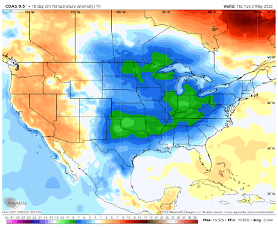
The times they are a changin'!  Here's a look at the temperatures anomalies (departure from average) for the past 10 days:

Temperature anomaly for the period April 22-May 21, 2023 (CDAS data via WxBell)

You'll notice the massive area of cold weather (relative to normal) that has encompassed the central and eastern U.S. Locally, it depicts temperatures that averaged about 8 degrees below normal for that 10-day period. We'll be transitioning out of that pattern over the next couple of days into something more akin to early summer as a large ridge of high pressure that was over the western U.S. shifts east. Here are the forecast temperature anomalies for Saturday through Wednesday, May 6-11:


The blue areas large turn orange (above average), while the western U.S. flips cool, as a large trough replaces the high pressure ridge out west, as it shifts east into the Plains. With average highs nearing 80 degrees this time of year in Memphis and lows near 60, above average means some of you who have wanted to see some 80s will get your wish! 

Weather pattern changing

With that warmth comes a significant increase in humidity as well, as dewpoints rise from the 30s (where they have been for several days) to the 60s, which is supportive of thunderstorms. And thus, an unsettled, warm, and humid forecast... just in time for the kickoff of Memphis in May's Beale Street Music Festival, back in Tom Lee Park for the first time in four years.

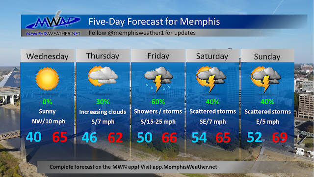
Enjoy the next couple of days as sunny skies and highs near 70 are expected Wednesday are followed by increasing clouds but still comfortable temperatures in the mid 70s Thursday. 

Opening day of Music Fest

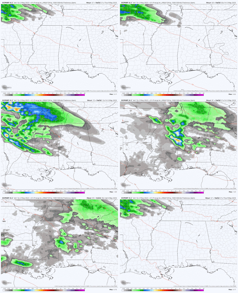
On Thursday night, a warm front moves north with humid air trailing and encounters "northwest flow" at the upper levels. This upper air pattern, which often occurs in late spring and summer, allows thunderstorm complexes from the Plains to move southeast into the mid/lower Mississippi Valley. It appears that we may be in for one of those early Friday, perhaps arriving pre-dawn. This doesn't present as a very severe event, but showers and thunderstorms are likely Friday morning, especially along and north of the broader I-40 corridor, including all of northeast AR and west TN. 

The Tuesday morning European model forecast precipitation from Thursday afternoon through Friday afternoon shows an area of precipitation diving southeast across the Mid-South in "northwest flow." (WeatherBell)

It appears that once morning rain moves out/dissipates, we'll have a moderately humid and warm afternoon with highs in the upper 70s and dewpoints rising into the lower 60s. There will be chances of shower or thunderstorm redevelopment in the afternoon and evening, but rain chances look lower during Music Fest gate hours than they are earlier in the day. Pack your cute rain boots or throw-away flip-flops though - it's not called Memphis in Mud for nothing!

Weekend forecast

The weekend forecast is less certain from a specificity standpoint, but overall appears to be very warm, humid, and capable of producing additional scattered showers and thunderstorms, depending on the existence and timing of upper level disturbances that move through the early summer airmass. If you're going to the river for great music this weekend, monitor forecasts leading until then and be prepared for showers on short notice!


This general pattern looks to stick around into early next week as no big cold fronts are currently on the horizon to bring sunny spring weather back, at least that we can pinpoint right now!

Erik Proseus
MWN Meteorologist

----
Follow MWN on Facebook and Twitter for routine updates and the latest info!
Complete MWN Forecast: MemphisWeather.net on the mobile web or via the MWN mobile app
Download our iPhone or Android apps, featuring StormWatch+ severe weather alerts!
MWN is a NOAA Weather Ready Nation Ambassador Meteorologist Erik Proseus is an NWA Digital Seal Holder