Friday, June 9, 2023

May 2023 Climate Report for Memphis, TN

May Climate Recap

After a cool start to the month, May warmed quickly and featured above average daily temperature readings for about two weeks. A bit of cooling resulted in near to slightly below normal temperatures for the remainder of the month however. Overall, the month was slightly warmer than a typical May, as seen in the cooling degree day numbers, which ended above average. The Mississippi River served as a proxy "border" between cool temperatures in the eastern U.S. and warmer temperatures to the west, particularly over the northern half of the western U.S. where warmth was particularly pronounced.


Rainfall was somewhat regular, though not exceedingly heavy, during the first half of the month. However after the 20th, rainfall was nearly non-existent, as evidenced by no measurable precipitation at the airport and only 0.02" in Bartlett. The airport recorded less than 40% of typical rainfall for the month as low end drought conditions (D0 - abnormally dry) started to appear in the western half of the greater metro area. May was also a fairly quiet month for severe weather with just a few reports of tree damage and hail on the 10th and 11th, when a few Severe Thunderstorm Warnings were also issued. The peak wind gust at the airport of 55 mph was recorded in one of those storms on the 11th.

Memphis International Airport, Memphis, TN

Temperature 
Average temperature: 72.6 degrees (0.5 degrees above average) 
Average high temperature: 82.2 degrees (0.5 degrees above average) 
Average low temperature: 63.1 degrees (0.7 degrees above average) 
Warmest temperature: 91 degrees (15th) 
Coolest temperature: 46 degrees (2nd) 
Heating Degrees Days: 18 (3 below average)
Cooling Degree Days: 260 (20 above average) 
Records set or tied: None
Comments: Three days reached 90 degrees, which is average for the month of May

Precipitation 
Monthly total: 2.05" (3.22" below average) 
Days with measurable precipitation: 7 (3.6 days below average) 
Wettest 24-hour period: 1.02" (11th-12th) 
Snowfall: None
Records set or tied: None
Comments: None

Miscellaneous 
Peak wind: South/55 mph (11th) 
Average wind: 7.4 mph 
Average relative humidity: 65%
Average sky cover: 53%

 Click here for a daily statistical recap for Memphis International Airport.
 

MemphisWeather.net Headquarters, Bartlett, TN

Temperature 
Average temperature: 71.1 degrees 
Average high temperature: 83.0 degrees 
Average low temperature: 60.5 degrees 
Warmest temperature: 93.3 degrees (15th) 
Coolest temperature: 42.9 degrees (3rd) 
Comments: None 

Precipitation 
Monthly total: 3.05" (automated rain gauge), 3.03" (manual CoCoRaHS rain gauge) 
Days with measurable precipitation: 8
Wettest date: 0.95" (11th) (via automated gauge) 
Snowfall: None
Comments: 62% of the month's precipitation fell on just two days

Miscellaneous 
Peak wind: Northeast/26 mph (2nd)
Average relative humidity: 71% 
Average barometric pressure: 29.99 in. Hg
Comments: None

Click here for a daily statistical recap for Bartlett, TN.
 

MWN Forecast Accuracy

MWN average temperature error: 1.97 degrees 
MWN forecast temperatures within 2 degrees of actual: 67% 
MWN average dewpoint error: 2.29 degrees 
MWN forecast dewpoints within 2 degrees of actual: 67% 

MWN's forecasts extend out five periods (2.5 days, or roughly 60 hours). Historical accuracy statistics can be found here.

----
Follow MWN on Facebook and Twitter for routine updates and the latest info!
Complete MWN Forecast: MemphisWeather.net on the mobile web or via the MWN mobile app
Download our iPhone or Android apps, featuring StormWatch+ severe weather alerts!
MWN is a NOAA Weather Ready Nation Ambassador Meteorologist Erik Proseus is an NWA Digital Seal Holder

Sunday, June 4, 2023

Cold fronts coming in the back door provide some relief

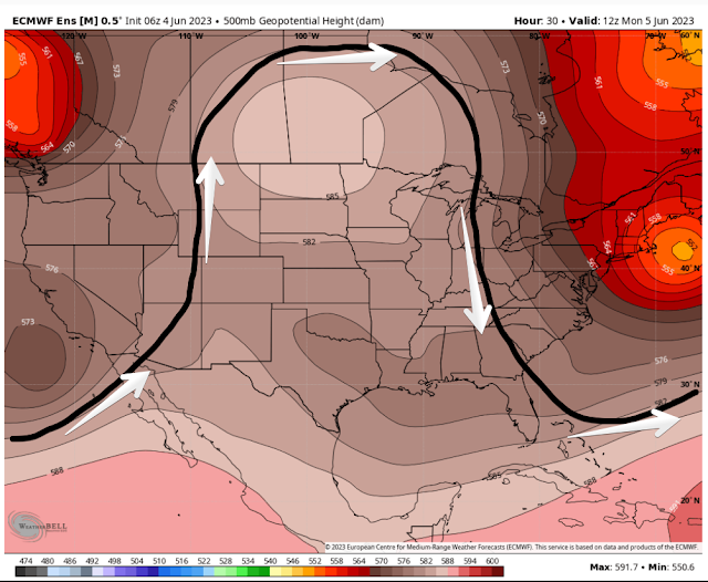
The early June weather pattern over the United Stated is a bit unusual - an "omega block" has set up in the upper levels of the atmosphere. This happens when the pattern becomes stagnant as a large ridge of high pressure sets up between two low pressure areas on either side of it. You can see this pattern in the image of the upper level pattern for Monday morning (below). Low pressure is positioned off the coast of California and over New England with high pressure situated over the central U.S. and Canada.


Under the ridge, well above normal temperatures occur, while cooler air sits under the lower pressure areas. As the relative positions of the low pressure areas shift, the edge of cooler and drier air also oscillates, while the overall pattern changes little. How does this affect the Mid-South? Glad you asked!

"Back door cold fronts" are the result of this shifting of the cooler/drier airmasses. If the normal movement of frontal systems is west-to-east, or northwest-to-southeast, those that come in the "back door" arrive from the northeast and move southwest. It's like a familiar neighbor or friend - they don't feel the need to knock, but usually their arrival is welcome anyway.


We've experienced a couple of those in the past week, and though the cooler air generally stays to our north, the recent drops in humidity on northeast wind have been a result of these welcome back door fronts! We'll have a couple more to watch in the coming week.

Early week

This weekend has been hot but not too humid as dewpoints (the best measure of absolute humidity in the atmosphere) have dropped into the 50s during the day - relatively comfortable when the weather is hot. Dewpoints will rise a bit into the low to mid 60s early this week ahead of the next cold front approaching from the northeast on Tuesday. That will mean a slight increase in afternoon thunderstorm chances (20-30%) and a bit stickier air as temperatures still manage to reach the lower 90s in the afternoon and stay near 70 in the early mornings. 

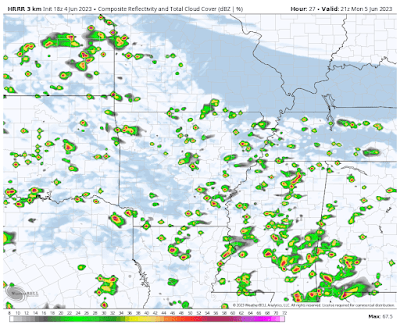
The HRRR model radar simulation for 4pm Monday shows a better chance of scattered showers and thunderstorms across the area. Note the northern edge of the scattered activity near the TN/KY line - where the back door cold front lies. (WeatherBell)

This first front stalls out Tuesday over the metro, resulting in highest rain chances in north MS and AR with drier air over west TN and Memphis near the dividing line between the two airmasses. By Wednesday, the front will basically wash out and we'll see continued low 90s for highs and dewpoints starting to creep back up again.

Late week

A more significant "back door" front will push through on Thursday, bringing with it increased thunderstorm chances (in the scattered range), but also a stronger push of dry air heading into Friday and Saturday. If everything stays on track, that front should bring a decent north wind and much drier air once again as we head to the end of the week. In fact, temperatures will drop a bit behind it as well - upper 80s for highs and mid 60s for lows Friday and Saturday - making for a pleasant few days. 


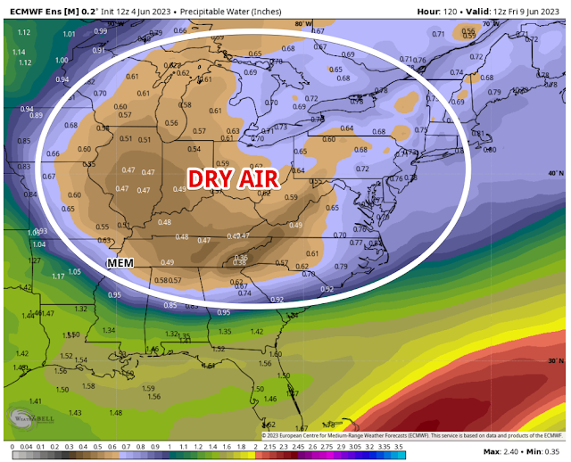
A massive wedge of dry air will back its way into our area by Friday morning according to the European model, and supported by other global models. This drier airmass will result in low humidity, slightly cooler temps, and dry conditions to start the weekend. (WeatherBell)

Return to wetter conditions?

By Sunday, it appears moisture starts to return and we could head into a bit more active pattern after that, which would be welcome news for those needing some relief from recent dry weather. It's been two weeks since the last good rainfall area-wide (though localized areas have benefited from spotty thunderstorms). With no more than a 20-40% chance of rain on any day this week, some of us could go nearly 3 weeks without beneficial rainfall, as we start inching our way into low-end drought conditions.

MWN staff transition

Finally, I would like to end with an update on who all is bringing you the daily weather information on our social media feeds. With the end of the spring semester in May, a few interns have moved on, while others have joined #TeamMWN! 


Those who have moved on to greener pastures: Kris Pitchford graduated from Mississippi State and is now working at ABC 33/40 in Birmingham as a News Producer (weather nerds may recognize that station as the home of the legend, James Spann!). Dorien Minor graduated with a master's degree from Georgia Tech and is now on-air with LIVE-5 News in Charleston, SC. Kailah Gordon received her bachelor's degree from #HailState and will pursue a master's degree while working full-time for EarthCast Technologies in the private sector. Finally, Carter Bentley also received his bachelor's from MSU and has a couple of weeks left with the team. We're grateful beyond measure for the contributions of these amazing young people and thank them for their service!

Arriving recently are Mississippi State University undergrads Lei Naidoo, Theo Cook and Kevin Conant. All are, or will soon be, appending their initials to social media posts from MWN and are excited to begin applying their classroom knowledge to the real world! And we're excited to have them on board! Follow our social channels listed below for routine updates each and every day.

Erik Proseus
MWN Meteorologist

----
Follow MWN on Facebook and Twitter for routine updates and the latest info!
Complete MWN Forecast: MemphisWeather.net on the mobile web or via the MWN mobile app
Download our iPhone or Android apps, featuring StormWatch+ severe weather alerts!
MWN is a NOAA Weather Ready Nation Ambassador Meteorologist Erik Proseus is an NWA Digital Seal Holder