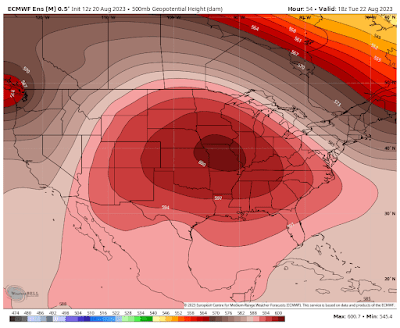
The wet and stormy pattern from late July through mid-August has evaporated as we head through the latter half of August. Several very comfortable days last week had most of us grateful for the arrival of #FalseFall. But a massive ridge of high pressure above us (a.k.a., a Heat Dome) will dominate a large portion of the country from the Rockies to the east coast, including the Mississippi Valley this week.
That will mean very hot temperatures under little cloud cover and increasing humidity this week. We'll likely see our first string of 100-degree temperatures since July 2022 as #SecondSummer arrives with a vengeance.
Fortunately, it appears that a cold front will move through next weekend as the high pressure ridge is suppressed to the south, allow temperatures to drop back to near average values around 90 degrees in about a week. Even with the cold front arriving, precipitation chances look to be very low, and on Saturday.
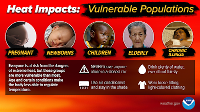
With heat indices near 110 degrees for a good part of the week, heat safety will be a necessity, especially with morning lows near 80 degrees providing little overnight relief. Heat Advisories will likely become Heat Warnings before it cools down a bit next weekend. Avoid the outdoors in the hottest part of the day, stay hydrated, take frequent breaks if you must be outdoors, and check on neighbors, the young and elderly, and your pets too!
Tropical action
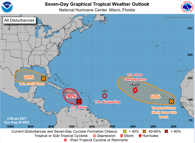
Meanwhile, the Atlantic Ocean tropical basin has sprung to life after a month of quiet conditions, and just as we begin the peak of the Atlantic hurricane season. Fortunately, only minor impacts are expected in the next several days as developing storms well out to sea will not affect the U.S. or Caribbean. A little closer to home, a system in the eastern Gulf of Mexico doesn't have optimal atmospheric conditions for development, but could become a tropical depression or weak storm as it moves towards south Texas in the next few days. That area of the country could use rainfall though, so rain would be beneficial in that region. Another system worth watching in the Caribbean is heading towards Hispaniola (Haiti and the Dominican Republic) and is likely to become Tropical Storm Franklin within the next day. It appears to miss Florida on an eventual track north.
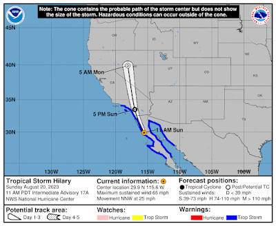 |
| Sunday afternoon forecast map for Tropical Storm Hilary (NHC) |
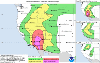 |
| Flash flood potential is high across southern CA into southwest NV. (NHC) |
Erik Proseus
MWN Meteorologist----
Follow MWN on Facebook and Twitter for routine updates and the latest info!
Complete MWN Forecast: MemphisWeather.net on the mobile web or via the MWN mobile app
Download our iPhone or Android apps, featuring StormWatch+ severe weather alerts!
 |  |
| MWN is a NOAA Weather Ready Nation Ambassador | Meteorologist Erik Proseus is an NWA Digital Seal Holder |



No comments:
Post a Comment