August Climate Recap
The month of August generally saw temperatures waver every few days from slightly above to slightly below normal. The exception was a string of hot days in the third week of the month, which resulted in four days hitting the century mark and nearly a week of average temperatures 5-10 degrees above normal. Multiple warm temperature records were also set during that late summer heat wave and a string of four consecutive days with temperatures no lower than 80 degrees (August 22-26) tied for fifth longest on record and is the latest (in the year) occurrence of a streak of three or more such days on record. The periodically cooler weather tempered the overall average for the month, which ended slightly above normal. An interesting note though was that that average was driven almost entirely by the overnight lows, which were more than a degree above normal. Average high temperatures for the month were right at average for August. For the period of meteorological summer (June-August), the average temperature for the three-month period of 81.4 degrees ended in the top 25% of all years (period of record: 149 years).

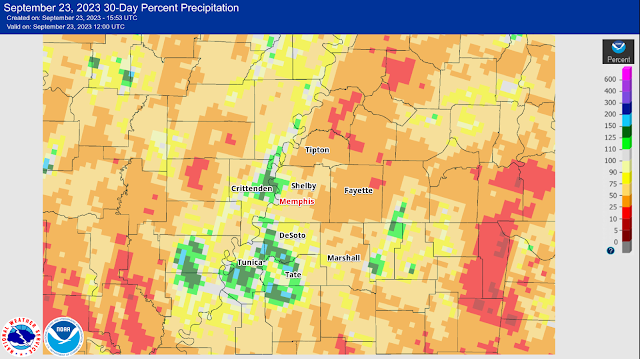
A wet summer to date continued for portions of the Memphis area as multiple rounds of heavy rain tracked across the northern metro during the month, resulting in over eight inches of precipitation in Bartlett. However, southern Shelby County and north MS missed out on much of this, with the airport recording just under three inches of rain for the month (much of that falling during storms on the 9th and 10th). The dry weather in the MS Delta region during both July and August resulted in drought conditions setting in mid-month in those agricultural areas. For the period of meteorological summer (June-August), total precipitation of 16.84" ended in the top 10% of all years (period of record: 152 years).
 |
| Departure from average rainfall for the Mid-South in August 2023. The precipitation disparity between northern and southern areas of the metro was stark, as evidenced by 8"+ of rainfall in Bartlett and less than 3" at Memphis Int'l in south Memphis. By the middle of the month, drought conditions had developed in the Mississippi Delta. (NOAA) |
An active summer severe weather pattern continued into early August with severe thunderstorms resulting in wind damage on afternoon of the 5th, followed by another round of midday storms on the 9th that brought large hail, damaging wind, and areas of flash flooding in Shelby County. A few strong storms also occurred mainly in Crittenden County on the evening of the 26th as the heat wave was broken by a cold front.
Memphis International Airport, Memphis, TN
Temperature
Average temperature: 82.6 degrees (0.5 degrees above average)
Average high temperature: 91.4 degrees (0.1 degrees below average)
Average low temperature: 73.8 degrees (1.2 degrees above average)
Warmest temperature: 102 degrees (25th, 26th)
Coolest temperature: 63 degrees (31st)
Heating Degrees Days: 0
Cooling Degree Days: 553 (25 above average)
Records set or tied: August 22, (80°, tied record warm low), August 23, (81°, set record warm low), August 24 (100°, tied record high), August 25 (102°, set record high; 80°, set record warm low), August 26 (80°, set record warm low).
Comments: 18 days reached 90°, which is 2.2 days below average for the month of August
Precipitation
Monthly total: 2.82" (0.55" below average)
Days with measurable precipitation: 8 (0.4 days above average)
Wettest 24-hour period: 2.17" (9th-10th)
Snowfall: None
Records set or tied: N/A
Comments: More than three-fourths of the total rain for the month fell in a 24-hour period over the 9th-10th.
Miscellaneous
Peak wind: North-northwest/51 mph (9th)
Average wind: 6.8 mph
Average relative humidity: 69%
Average sky cover: 42%
Click
here for a daily statistical recap for Memphis International Airport.
MemphisWeather.net Headquarters, Bartlett, TN
Temperature
Average temperature: 79.6 degrees
Average high temperature: 90.5 degrees
Average low temperature: 70.8 degrees
Warmest temperature: 99.8 degrees (5th)
Coolest temperature: 58.8 degrees (31st)
Comments: None
Precipitation
Monthly total: 8.20" (automated rain gauge), 8.09" (CoCoRaHS rain gauge)
Days with measurable precipitation: 8
Wettest date: 3.33" (9th) (via automated gauge)
Snowfall: None
Comments: Bartlett received over five inches more rain than fell at the airport, or almost 300% of the airport total. In fact, more rain fell on August 9 in Bartlett than the airport received for the entire month. The July-August total for Bartlett was well over 16 inches.
Miscellaneous
Peak wind: Southwest/28 mph (5th)
Average relative humidity: 79%
Average barometric pressure: 29.95 in. Hg
Comments: None
Click
here for a daily statistical recap for Bartlett, TN.
MWN Forecast Accuracy
MWN average temperature error: 1.99 degrees
MWN forecast temperatures within 2 degrees of actual: 76%
MWN average dewpoint error: 1.70 degrees
MWN forecast dewpoints within 2 degrees of actual: 72%
MWN's forecasts extend out five periods (2.5 days, or roughly 60 hours). Historical accuracy statistics can be found
here.
----
Follow MWN on
Facebook and
Twitter for routine updates and the latest info!
Complete MWN Forecast:
MemphisWeather.net on the mobile web or via the
MWN mobile app
Download our
iPhone or Android apps, featuring
StormWatch+ severe weather alerts!
 |  |
| MWN is a NOAA Weather Ready Nation Ambassador | Meteorologist Erik Proseus is an NWA Digital Seal Holder |
.png)


.gif)

.gif)

