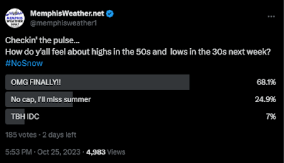
According to a recent poll we conducted on X, nearly 70% of you are ready for late summer warmth to end and "deep fall" to begin.
Well, your wish is my command! But first, let's try and get a little drought relief after suffering through less than two inches of rain since September 1. Unfortunately, rain chances are increasing over a fairly busy Halloween/fall fest weekend!
.png) |
| The most recent Drought Index map shows the majority of the metro in a severe (D2) drought after weeks of very little rain. (UNL) |
Pre-frontal warmth and rain
A seriously cold Canadian front will ooze through the Mid-South late this weekend. However, it will be close enough the next 48 hours to bring off and on rain chances. We'll still be on the warm side of it until at least midday, or maybe evening, on Sunday so mild temperatures continue, but not quite the 80s we have had the past week. Rain will be spotty through mid to late afternoon Saturday before the next organized round of showers moves in and blankets the area Saturday evening. You'll want a Plan B for any outdoor activities starting at dinner time Saturday. Temperatures should remain mostly in the 70s after starting in the mid 60s Saturday morning.
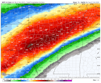 |
| NWS forecast rainfall amounts through Monday show the potential for 1-2" across the metro with higher amounts over AR where the front stalls this weekend. (WPC/WxBell) |
Showers will continue to be scattered Sunday ahead of the front, then become increasingly likely along and behind it as we head into Sunday night. We could stay in the 60s Sunday, but at best we'll see lower 70s if there are long enough breaks in the showers.
Arrival of Canadian air
As cold air moves in Sunday night, rain continues to fall, lasting until probably mid-day Monday. And boy will it be COLD after we've been acclimated to 70s and 80s lately! (No, not cold enough for s**w though!) Monday morning we'll wake up to showers, a cold north wind, and temperatures in the mid 40s. And with rain still around and clouds not departing until late in the day, we may well not see temperatures rise at all as cold air continues to advect in on breezy north wind!
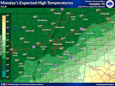 |
| Expected high temperatures (not lows!) on Monday (NWS) |
The rest of the week, starting Tuesday morning, will feel more like December or January despite abundant sunshine. Morning lows will likely drop to freezing - even in the city - while some upper 20s are possible in coldest outlying areas on Wednesday and Thursday mornings. High temperatures look to be near 50 degrees Halloween Day and Wednesday before rebounding a bit on Thursday, then back into the low 60s by week's end. Bundle up those trick-or-treaters as wind chills will be in the 30s Tuesday evening!
 |
| Probability of freezing temperatures Wednesday morning (NWS) |
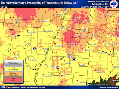 |
| Probability of a hard freeze (28°) on Thursday morning. (NWS) |
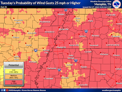 |
| Potential for wind gusts over 25 mph is high on Halloween Day. Paired with max temperatures near 50, it will be a COLD night of trick-or treating! (NWS) |
If you have outdoor winterizing that needs to be done - this weekend is the time to do it! Hose bibs should be covered, exterior doors sealed, and sensitive plants brought into the garage or indoors for a few days next week. Fortunately, the cold snap should only last a few days, as we'll be back to near normal (that's highs in the upper 60s and lows in the mid 40s) as we head into next weekend.
Is your winter emergency car kit stocked and updated? Remember to include the following items:
— Memphis Office of Emergency Management (@MEMPHISOEM) October 27, 2023
🔦Flashlight + extra batteries
🚘Jumper cables
🧥Warm clothes & blankets
🍿Non-perishable snacks
More info: https://t.co/xQixVyiTwq@Readygov @NWSMemphis @memphisweather1 pic.twitter.com/WBOO5vo7My
Erik Proseus
MWN Meteorologist----
Follow MWN on Facebook and Twitter for routine updates and the latest info!
Complete MWN Forecast: MemphisWeather.net on the mobile web or via the MWN mobile app
Download our iPhone or Android apps, featuring StormWatch+ severe weather alerts!
 |  |
| MWN is a NOAA Weather Ready Nation Ambassador | Meteorologist Erik Proseus is an NWA Digital Seal Holder |

No comments:
Post a Comment