A generally cool and dry pattern changes for a few days as we head to the end of November and into the last month of 2023. A storm system exiting the Rockies and heading across the southern Plains and into the Deep South will bring us rainfall and perhaps a few thunderstorms in the next 36 hours. It could also affect your outdoor Christmas decor! But it is also a weekend chock full of seasonal activities, so what about rain chances and temperatures for the weekend? Let's dive in!
Thursday/Thursday night
A bit milder weather is expected tonight with southerly wind and high clouds moving in as temperatures only reach the 30s in rural areas. The rest of us will see lows at or above 40 tonight. Clouds thicken tomorrow as low pressure moves through the southern Plains and rain spreads towards the Mid-South, arriving around mid-afternoon as temperatures peak near 60. Rain picks up heading into the evening with a few rumbles of thunder possible as well.
 |
| Forecast precipitation via the NWS National Blend of Models shows totals should generally run above a half inch, but less than an inch in the metro. (WeatherBell) |
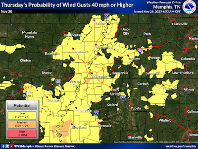
Southerly wind also increases Thursday night with frequent gusts to 30 mph and a few possibly approaching 40 mph! A Wind Advisory has been issued so make sure the outdoor decor is tied down well, or maybe just moved inside if possible for those inflatables! Temperatures remain mild overnight - in the 50s - as rain falls much of the night.
 |
| Probability of wind gusts exceeding 40 mph on Thursday (night). Frequent gusts above 30 mph are likely. (NWS-Memphis) |
Friday/Saturday
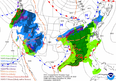
Most rain will be gone by Friday morning, but with the front still to our west as it's parent low pressure center moves into the mid-Mississippi Valley, it will remain mild with a breezy southwest wind. High temperatures should be well above average despite persistent cloud cover, peaking in the upper 60s.
 |
| The Friday morning weather map shows rain moving to the east as a cold front approaches from the west. The front arrives Friday evening dry. (NWS/WPC) |
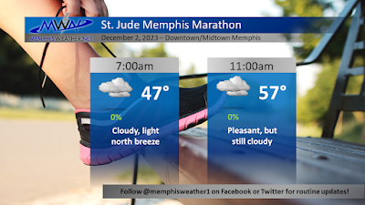
Behind the cold front on Friday evening (which will pass through with no additional rainfall), temperatures drop to the mid to upper 40s Saturday morning before rising to the lower 60s in the afternoon. Clouds will continue to stream overhead with a north wind at 5-10 mph. Overall, it should be a pretty good day for the St. Jude Memphis Marathon and other outdoor activities.
Sunday and beyond
As the late-week system finally pulls to the east, sunshine returns Sunday and continues through the first half of the week, at least. Temperatures will be a bit cooler, but not cold, with lows mostly in the 40s and highs in the upper 50s to low 60s until Wednesday when it gets a bit cooler. Overall, not much to complain about with this forecast!
Erik Proseus
MWN Meteorologist
----
Follow MWN on Facebook and Twitter for routine updates and the latest info!
Complete MWN Forecast: MemphisWeather.net on the mobile web or via the MWN mobile app
Download our iPhone or Android apps, featuring StormWatch+ severe weather alerts!
 |  |
| MWN is a NOAA Weather Ready Nation Ambassador | Meteorologist Erik Proseus is an NWA Digital Seal Holder |


No comments:
Post a Comment