Pages

Saturday, April 27, 2024

All-NEW MemphisWeather.net coming soon!

Background

MemphisWeather.net began in 2003 as an expansion of a personal website ("Erik's Memphis Weather Page") that was designed primarily for friends and family to get local forecasts and other Memphis-centric weather information. With a brand established, word got out and the website visitor numbers grew - slowly most of the time, but by larger numbers during "big weather events." In 2007, the website was redesigned and a mobile version of the site was released a year later.

The front page of MemphisWeather.net as it looked in 2005. Who remembers this??

With the advent of social media in the late 2000's and launch of our first mobile app in 2011, the site's visibility was boosted across the greater Memphis metro. MWN, as it came to be called, continued a steady growth phase and the site itself grew as well, adding more pages and features. The framework of the main website and its mobile counterpart, however, did not change.

Upcoming changes

It has been 17 years since the last major refresh of the site as we sit at a bit of a crossroads. Mobile app development costs have increased significantly. Routine app updates are basically required to meet store specifications and remain compatible with device improvements and new features. However, the majority of us are using our phones for just about everything, so being "mobile friendly" remains vital. The main MWN website was built for full screen viewers (desktops/laptops), while the mobile site has remained fairly basic. Given a need for a flexible web presence, and also our desire to continue to invest in app development for StormWatch+ to serve a national audience, we made the choice to rebuild the MWN web experience to reach users with an array of content accessible on all platforms, while bidding farewell to the legacy MWN app. (More on that in a minute.)

MWN in 2024

The all-new "2024 version" of MemphisWeather.net (preview below) is very close to being released! So what can you expect from the new MWN? 
  • A completely new and modernized web layout, with distinct mobile and full-screen experiences, built on a single platform for ease of maintenance and upkeep.
  • A seamless integration of the MWN Blog, as the site is built on WordPress and all previous blog posts will be migrated to the new site.
  • All of the content you have come to expect from MWN, plus an expanded offering of products for the mobile user!
  • Opt-in "push notification" style messaging to keep you updated - on new content, approaching severe weather, or even maintenance events - in a proactive fashion.
  • New technology that allows you to drop MWN onto your phone's home screen, launching and interacting with it just like a mobile app, without requiring us to spend big bucks to develop standalone mobile apps. A win-win!

MWN mobile app being sunset

Returning to the legacy MWN mobile app, we are aware that it has fallen into a bit of disrepair of late, but unless we completely rebuild it to the latest requirements of the app stores, we were unable to just fix the little things. Therefore, with the release of the new website, the current MWN app will be removed from the app stores and no longer supported. (We'll provide easy steps to create the "app experience" you are used to with the new site, so stay tuned!)

Unfortunately, this change also means that the push notification-based severe weather alerts in the MWN app (StormWatch+ Alerts) will also no longer be available at some point in the near future. We know that a LOT of you rely on these alerts from the MWN app. Not to worry! We will be providing information on transitioning to our recently rebuilt StormWatch+ app with nationwide severe weather alerting, which offers enhanced features as compared to MWN alerts. More on this in the near future as well!

Thank you!

We're grateful for the thousands of you who are longtime MWN "fans," and appreciate the trust you place in MWN for your local weather needs! We'll work with you through the transition to ensure that your overall MWN experience is a positive one! Further information on the new site, how to consume the information from it, and transitioning to the StormWatch+ app for alerts, will be communicated through social media, on our site and in this blog. Thank you for your continued support in the weeks, months, and years ahead!

 Erik Proseus & Richard Hoseney
Co-Owners/Meteorologists
Cirrus Weather Solutions, LLC
MemphisWeather.net and StormWatch+


----
Follow MWN on Facebook and Twitter for routine updates and the latest info!
Complete MWN Forecast: MemphisWeather.net on the mobile web or via the MWN mobile app
Download our iPhone or Android apps, featuring StormWatch+ severe weather alerts!
MWN is a NOAA Weather Ready Nation Ambassador Meteorologist Erik Proseus is an NWA Digital Seal Holder

Sunday, April 14, 2024

Severe weather season delivers a couple thunderstorm chances this week

We've made it into the heart of spring, which means we're also into spring severe weather season, which continues for the next month to six weeks. High temperatures in the 80+ range are 5-7 degrees above normal, so with a couple of frontal systems moving through this week, we'll need to keep an eye on the threat for strong storms. 

Tuesday

The first of those threats, and the one with the highest potential, arrives Tuesday evening. Ahead of the front, breezy south wind and an approaching upper level trough will bring high moisture levels into the region from the Gulf of Mexico. As the front approaches, thunderstorms are likely to erupt to our west and move east, reaching the area late afternoon to evening. 

The European model predicts atmospheric moisture content over the area to be near 200% of normal on Tuesday evening, more than enough to support strong to severe storms and locally heavy rain. (WeatherBell)

Strong wind at the surface (expect gusts as high as 40 mph Tuesday) and aloft, along with available storm fuel created by temperatures near 80 and dewpoints in the mid 60s, should allow the storms to be strong to severe, especially in areas near and west of the river, including the metro. For now, a Level 2 (Slight) risk of severe weather is forecast for this area, but will probably be tweaked a bit in the next 48 hours. The primary threat will be damaging wind, but a couple of tornadoes can't be ruled out. The threat should end before midnight as it currently stands. Stay in touch the next couple days.


Thursday

Looking beyond Tuesday night's front, the atmosphere won't cool off much and moisture levels return to high levels by Thursday as the next front heads our way. The severe threat appears lower with this front, despite it being more potent in terms of trailing cool air, as there will not be the dynamics created by strong low pressure accompanying it. It's still several days out, so we'll keep an eye on it for any changes. Behind that front, much cooler air arrives for next weekend, with the potential for additional showers, as highs drop back to the 60s for a few days.

The European model simulated infrared satellite imagery shows the potential for a line of thunderstorms along a cold front on Thursday evening. (WeatherBell)

Erik Proseus
MWN Meteorologist

----
Follow MWN on Facebook and Twitter for routine updates and the latest info!
Complete MWN Forecast: MemphisWeather.net on the mobile web or via the MWN mobile app
Download our iPhone or Android apps, featuring StormWatch+ severe weather alerts!
MWN is a NOAA Weather Ready Nation Ambassador Meteorologist Erik Proseus is an NWA Digital Seal Holder

Tuesday, April 9, 2024

March 2024 Climate Report for Memphis, TN

March Climate Recap

The month of March was warmer than normal by almost three degrees. High temperatures ranged from the 50's to the low 80's, while lows ranged from 29 to the low 60's. Overall, only 11 days during the month saw an average temperature below normal (as low as 13 degrees below normal), while some days were as much as 20 degrees above normal.

Departure from normal temperatures for March for the Lower 48 states

Precipitation was nearly an inch below normal for the month. The wettest period was between the 14th-15th at 2.12" at the airport, while MWN headquarters in Bartlett saw 1.49" during that time. Totals for the month ended up at 4.90" at the airport and 3.79" in Bartlett.

As far as lingering drought goes, there was continued improvement across the area. Much of the portion of the Memphis metro in west Tennessee is now out of drought status, while northwest Mississippi continues in a abnormally dry to moderate drought, but has also seen improvement in the past month.

Drought conditions as of April 2, 2024 (UNL)


Change in drought conditions over 4 weeks as of April 2, 2024 (UNL)


Memphis International Airport, Memphis, TN

Temperature 
Average temperature: 57.0 degrees (2.8 degrees above average) 
Average high temperature: 66.7 degrees (2.5 degrees above average) 
Average low temperature: 47.3 degrees (3.0 degrees above average) 
Warmest temperature: 81 degrees (4th) 
Coolest temperature: 29 degrees (19th)
Heating Degrees Days: 260 (92 below average)
Cooling Degree Days: 19 (1 above average) 
Records set or tied: Record high tied (81° on the 4th)
Comments:  None

Precipitation 
Monthly total: 4.90" (0.84" below average) 
Days with measurable precipitation: 9 (2.5 days below average) 
Wettest 24-hour period: 2.11" (14th-15th) 
Snowfall: None (0.5" below average)
Records set or tied: None
Comments: None

Miscellaneous 
Peak wind: Southeast/55 mph (25th) 
Average wind: 8.2 mph 
Average relative humidity: 65%
Average sky cover: 56%

 Click here for a daily statistical recap for Memphis International Airport.
 

MemphisWeather.net Headquarters, Bartlett, TN

Temperature 
Average temperature: 57.0 degrees 
Average high temperature: 68.3 degrees 
Average low temperature:  45.6 degrees 
Warmest temperature: 83.0 degrees (4th) 
Coolest temperature: 27.4 degrees (19th) 
Comments: None

Precipitation 
Monthly total: 3.66" (automated rain gauge), 3.78" (CoCoRaHS rain gauge) 
Days with measurable precipitation: 7
Wettest date: 1.72" (25th) (via automated gauge) 
Snowfall: None
Comments: None

Miscellaneous 
Peak wind: South/34 mph (25th)
Average relative humidity: 67% 
Average barometric pressure: 30.01 in.
Comments: None

Click here for a daily statistical recap for Bartlett, TN.
 

MWN Forecast Accuracy

Average temperature error: 2.06 degrees 
Forecast temperatures within 2 degrees of actual: 71% 
Average dewpoint error: 2.21 degrees 
Forecast dewpoints within 2 degrees of actual: 69% 

MWN's forecasts extend out five periods (2.5 days, or roughly 60 hours). Historical accuracy statistics can be found here.

----
Follow MWN on Facebook and Twitter for routine updates and the latest info!
Complete MWN Forecast: MemphisWeather.net on the mobile web or via the MWN mobile app
Download our iPhone or Android apps, featuring StormWatch+ severe weather alerts!
MWN is a NOAA Weather Ready Nation Ambassador Meteorologist Erik Proseus is an NWA Digital Seal Holder

Saturday, April 6, 2024

Eclipse, severe storms, and heavy rain - oh my!

Next week will be a busy week to be a meteorologist! Let's set expectations as we head into it...


Saturday

The cooler weather of the past few days is relenting as high pressure shifts east and a southerly flow of air moves over the region. Temperatures will moderate today, especially once morning high clouds depart, allowing for highs in the upper 60s. A perfect day to begin your outdoor planting, as it appears the frost potential is probably over for the spring.


Sunday

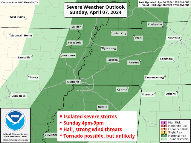
A weak front moves into the area Sunday night. Ahead of it, south wind will become gusty, reaching 30 mph in the afternoon, and temperatures will reach the mid 70s as clouds also increase. We'll see scattered showers and a few t'storms, mainly in the afternoon and evening. A couple of these storms could get a little feisty from late afternoon until just after sunset, so the Storm Prediction Center has outlooked the area for a Marginal Risk of a severe storm. That's just a level 1 on the 5-point scale, so no widespread problems are affected, but isolated storms could have some hail or gusty wind, and a brief tornado can't be completely ruled out due to the wind shear in place. All of this comes to an end by 9-10pm.


Eclipse Day!

We've been watching this closely every day for the past week and are finally getting into a window of time where our high-resolution models are seeing the early afternoon hours Monday, offering more guidance on the forecast. I am fairly confident that morning low clouds will occur as the Sunday night front washes out over us. I'm also confident that conditions will remain dry through the afternoon. 


Confidence dips a bit as we look at lingering clouds Monday afternoon when the eclipse occurs. Morning clouds should be breaking up by noon, but to what extent remains to be seen. The most likely scenario is that they will mostly clear during the afternoon, but timing is a bit uncertain. Also, high thin cirrus clouds will be arriving in the afternoon. These will have less effect on eclipse viewing. Like a 5-year-old lying about whether he broke your favorite vase, you should be able to see right through those. All that said, I think there is a good chance the eclipse will be visible at times during the nearly 3-hour event. At maximum eclipse around 2pm? Here's hoping we all get a glimpse! 

Forecast cloud cover at the time of the eclipse on Monday afternoon, courtesy NWS-Memphis

For those heading west, in general, a similar forecast for the I-40 corridor in Arkansas. There is probably a better chance of decent viewing conditions north of I-40 than south of it due to those lower clouds. However, for the experience of totality that simply cannot be matched in a 97% coverage area like Memphis, it's worth the trip in my book, and I'm taking the opportunity! 

We'll start to see those clouds to our south pull further north as the afternoon and evening progress, both here and in Arkansas, as a very wet pattern starts to set up. Monday night could see the first of several rounds of showers and thunderstorms as a warm front moves north. A few of those storms could contain marginally severe hail and some wind gusts overnight.


Tuesday-Thursday

We're expecting what may be more wet hours than dry for a couple of days mid-week, with bouts of thunderstorms embedded in rain. Some of those could be strong, especially Wednesday to Wednesday night, though more likely in north MS and southern AR than west TN. With repeated rounds of rainfall, multiple inches of pollen-cleansing rain are in order! We'll hope the severe stuff stays away, but you'll want to stay in touch for further updates as overnight storms are a possibility. 


By Thursday, low pressure responsible for all the rain will be moving through the Mid-South, tapering the stormy weather off to showers. By Friday, rain should be done and the drying process can commence as we head into the middle weekend of April. Overall, temperatures throughout the mid- to late-week period will be mild as high temperatures will be within a few degrees of 70 and lows will fall only into the 50s and 60s. 


Here's to amazing eclipse viewing conditions and sturdy umbrellas next week!

Erik Proseus
MWN Meteorologist

----
Follow MWN on Facebook and Twitter for routine updates and the latest info!
Complete MWN Forecast: MemphisWeather.net on the mobile web or via the MWN mobile app
Download our iPhone or Android apps, featuring StormWatch+ severe weather alerts!
MWN is a NOAA Weather Ready Nation Ambassador Meteorologist Erik Proseus is an NWA Digital Seal Holder